Tuesday, September 29, 2009
ULI's UrbanPlan - Lessons in Development
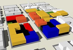
There are a lot of trade-offs to balance if you are developing land. UrbanPlan program, which is incorporated into selected high schools through economics or government courses, sets up a scenario that tests the trade-offs. In it, teams of 5, a marketing director, a site planner, a financial analyst, a city liaison, and a neighborhood liaison have to respond to an RFP. It was developed at UC Berkeley through the Fischer Center at the Haas School of Business. Now, it has gone national through ULI. I was there at the beginning, I drew the site plan, I contributed to some of the graphics in the workbook, and I implemented the program for ED1 at UC Berkeley. The process has matured and many students have now experienced the juggling act of public-private partnerships. I'm still going strong as a facilitator, and from time to time, on the Yorktown City Council as a juror.
Saturday, September 19, 2009
The Back of Pacific Garden Mall, Santa Cruz
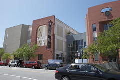
What do you do with the backsides of large buildings? Some designers leave them blank, which is deadly to the street behind. Here the treatment of the backside of buildings that face onto Pacific Garden Mall provides some variation and pays attention to the it's backstreet. It breaks down the massiveness of the parking structure, to the left. There is a setback to a passageway (through the grey-blue building) that gives a little more space to the public realm. These moves are done in the character of the existing building to the right, which looks like it was older, and has been updated (possibly to improve its earthquake resistance?)
Friday, September 18, 2009
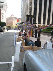
Parking Day 2008
Today is PARKING DAY! It is a day where we pay for "parking" and put a park there instead of a car. Social/green space takes over the automobile realm... OK, so this was our entry last year, it seems that our meter ran out on us this year. But, it is worth revisiting our park idea: we reused our office materials to construct our park. We used boxes for park benches and made a tree out of our discarded business cards.
Here is an interesting coverage of 2009 on Streetsblog and Streetfilms both a part of the Livable Streets Initiative.
Here is an interesting coverage of 2009 on Streetsblog and Streetfilms both a part of the Livable Streets Initiative.
Wednesday, September 16, 2009
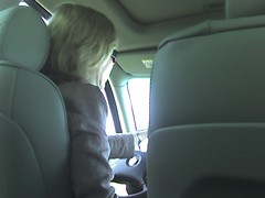
Casual Carpool
This is Bay Bridge phenomenon that I have tried to capture for a long time.
"Casual car pools" or "ad hoc car pools" are informal car pools that form when drivers and passengers meet – without specific prior arrangement – at designated locations.
There are lots of great stories that come from this spontaneous method of commuting. It's a great convenience as well as a social experiment. I have taken it the Oakland Avenue, Park and Hampel, and College and Claremont locations. There are only a few drivers I've encountered more than once. There are many funny stories, and few scary ones (let's keep it that way!)
There are many opinions about the experience. And, it seems there are some who have written books and many who have written articles on the subject. I like this video about casual carpool. The stuff that happens in these cars is stuff worthy of putting on-screen.
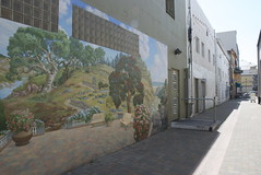
Public Art in Santa Cruz
This mural is located on Pearl Alley in Santa Cruz. The alley is narrow at this point, but the mural helps make it look bigger. And, park like (see benches)! It features some of the local landscape. This alley allows pedestrians connect from parking areas behind shops on Pacific Avenue, the main shopping street. This alley is nice enough and intimate enough for restaurants to want to open up to it.
Wednesday, September 9, 2009
How Bears Study the Environment
My alma mater, the College of Environmental Design at UC Berkeley (Go Bears!), is going to celebrate its 50th anniversary this year. While there are plenty of parties, lectures, and exhibitions, the enduring product of this place is the research that helps shape the way we understand the built environment. These following research centers utilize the interdisciplinary possibilities among the three departments (architecture, landscape architecture, and city planning.)
- The Center for Environmental Design Research (CEDR) fosters research in environmental planning and design, ranging from the local environments of people within buildings to region-wide ecosystems, from small details of building construction to large-scale urban planning, from the history of the built environment to the design process itself. CEDR manages and edits Places, the main journal in the U.S. principally focused on urban design.
- The Institute of Urban and Regional Development (IURD) helps scholars and students understand the dynamics of communities, cities, and regions while informing public policy at local, state, and national levels.
Wednesday, September 2, 2009
Toolkits and Street Design Manuals
Big cities are thinking about street design and producing very helpful design manuals that serve to educate and encourage new development that make better places. Amber Hawkes and Georgia Sheridan look at some of the emerging street design manuals and give an in-depth review on how they're working. Street design manuals are also being used as tools that shape smaller, more suburban cities. Though, the bigger cities, with bigger budgets, generally have more graphically appealing and educational documents.
Tuesday, September 1, 2009
Walnut Creek Shuttle Route 4
Here it is! Free public transportation. Will you still drive? Yes! Why? How successful is the route? How is it supported? Why don't you use it?
Route 4 connects the Walnut Creek BART Station to the extensive downtown and all the major parking structures. And, it looks like a trolley not a bus, which should make it even more inviting.
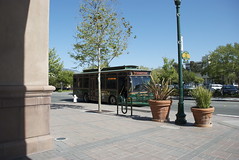
Route 4 connects the Walnut Creek BART Station to the extensive downtown and all the major parking structures. And, it looks like a trolley not a bus, which should make it even more inviting.
Daylit Creek in Temescal
Temescal Creek is a daylit creek that links together Hardy "Frog Park" and Little Frog Park and runs by the DMV and the Temescal Farmer's Market that occurs in the DMV parking lot on Sunday Mornings.

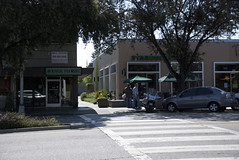
Mid Block Alley on California Ave
Parking is located behind the stores on California Avenue, which helps to define and concentrate the activity on the street. This would have been a long block to walk around if not for the alleys that allow people through at frequent intervals.
Changes in Oakland
There are many plans and changes coming to Oakland in the next few years. Here are three:
1. The Broadway Valdez District Specific Plan will be a framework plan that will look at a retail enhancement strategy for the upper Broadway area. The next Public workshop will be November 5, 2009 where Project Alternatives will be presented.
2. The Kaiser Medical Center Rebuilding, which is now under construction. A history of the M/B Center that being demolished at the moment is contained in a PANIL (Piedmont Avenue Neighborhood Improvement League) newsletter. This megablock is an interesting experiment in urban planning that was always too big to be a successful place.
3. Renovations to the Pleasant Valley Safeway and Longs (a.k.a. "Big Longs"). Living in the O has a post about the community meetings. This is a big box, car-oriented shopping center. Pre-application plans show a little more intensification at the site, with the replacement of Big Longs.
Subscribe to:
Posts (Atom)